You’ve likely heard of aquifers, but do you really know much about them?
Aquifers are natural underground areas that hold enough water to provide a usable supply to those who live and work above it. Some of the largest aquifers in Texas, including the Ogallala and Gulf Coast, are made up of sand and gravel. The Edwards Aquifer in south central Texas is a karst aquifer, which means it consists of porous, honeycombed formations of limestone where water travels and is stored underground.
Aquifers hold vast amounts of underground water and extend beneath about 81% of Texas. They aren’t necessarily massive underground caves, though some exist in that form. The water an aquifer holds lies mixed in the ground with rocks, sand, limestone, and other porous materials.
Texas aquifers are vital to the survival of life and our economy. Aquifers provide water to residential homes, commercial businesses, and agriculture operations. Let’s not forget all the animal and plant life that depend on the water from aquifers. That’s why we must do all we can to protect them.
While aquifers are rechargeable, they recharge (or, refill) themselves at different rates. If users are pulling out more water than is going back into the aquifer, the supply will start to dwindle.
Also, when harmful chemicals are dumped on the ground or into storm sewers or waterways, they are likely to find their way into an aquifer. Those chemicals contaminate the water beneath your feet and can find their way into our water supply.
Being armed with some knowledge about the aquifer you live above may give you and your neighbors a powerful incentive to conserve water and keep your local watershed clean.
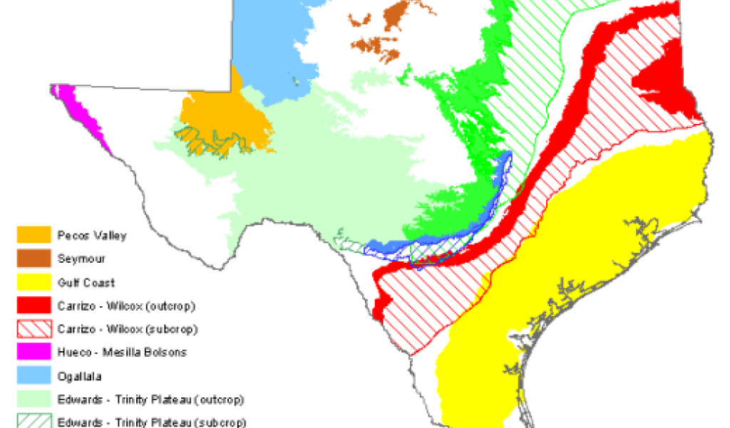
West Texas is the home of the Pecos Valley Aquifer. Ward, Reeves, Loving, Winkler, Crane, Ector, Upton and Pecos counties draw water from this aquifer.
The water quality is highly variable depending on where the water is drawn. It’s characterized by high levels of chloride and sulfate in excess of secondary drinking water standards. Broadly speaking, the water is hard, containing traces of silica, iron, sulfate, chloride, arsenic, and radionuclides. Rest assured that the water is tested and treated for quality.
The Gulf Coast Aquifer forms a semi-crescent shaped belt that parallels the Texas coast and extends through 54 counties from the Rio Grande northeastward to the Louisiana border. This includes major Texas cities like Beaumont, Houston, Galveston, Corpus Christi, and McAllen.
In parts of Harris, Galveston, Fort Bend, Jasper, and Wharton counties, the water level has declined by as much as 350 feet and has led to land subsidence, otherwise known as “sinking.”
The Carrizo-Wilcox Aquifer extends from the Rio Grande in South Texas northeastward into Arkansas and Louisiana, providing water in 60 counties.
Municipal pumping accounts for about 35% and irrigation pumping accounts for about 51% of the total water pumped. The largest metropolitan areas that depend on the groundwater from this aquifer are Bryan-College Station, Lufkin-Nacogdoches, and Tyler. Irrigating for agriculture is the predominant use in the Winter Garden region of South Texas where the water quality is slightly to moderately saline.
Sand makes up most of the Carrizo-Wilcox, although it also contains layers of gravel, silt, clay, and lignite. It’s recharged with water from rainfall or from streams that cross the outcrop and lose a portion of their flow to the underlying sands.
Covering most of the High Plains and nearly the entire Panhandle, the Ogallala Aquifer is the largest aquifer in the United States, covering over 36,000 square miles. It crosses state lines, stretches from Texas and winds its way north, providing water to parts of New Mexico, Oklahoma, Kansas, Colorado, Nebraska, South Dakota, and Wyoming.
The Ogallala Aquifer provides significantly more water for users than any other aquifer in Texas. About 95% of water from the Ogallala is used for irrigating crops.
The Edwards Aquifer extends in a band through the central part of the state from the Red River to the eastern edge of Bandera and Medina counties, and the Trinity-Edwards Plateau Aquifer covers all or part of over 20 counties from Gillespie to the Trans-Pecos region of west Texas. Together, they are the primary water source for most of the Hill Country.
The Edwards Aquifer is a home to diverse animals and is a drinking water source for the city of San Antonio and surrounding central Texas communities. Because it is a karst aquifer, fractures, caves, sinking streams, and sinkholes act as conduits to the aquifer from the surface. While this means that the aquifer recharges quickly after a rain event, it also means that any surface pollution from stormwater runoff or spills will directly impact the water quality of the aquifer, possibly fouling drinking water and affecting the sensitive ecosystem.
Eight species that live in the Edwards Aquifer ecosystem are either threatened or endangered.
Check the Edwards Aquifer webpage for up-to-the-minute updates on the Aquifer’s levels.
The Trinity Aquifer extends in a band across much of central and northeastern Texas. It’s composed of several smaller aquifers contained within the Trinity Group. These aquifers consist of limestones, sands, clays, gravels, and conglomerates.
Unlike the Edwards, the Trinity Aquifer recharges very slowly. Only 4-5% of water that falls as rain over the area recharges the aquifer, and water also moves through the Trinity much more slowly than through the Edwards.
Some areas of the Trinity serve as a catchment area for the Edwards Aquifer. Even though users in the Hill Country use the Trinity Aquifer they are involved in Edwards Aquifer issues, especially regarding restrictions on development or discharges that affect the quality of water that eventually ends up as Edwards recharge.
Learn more about the nine major aquifers and 22 minor aquifers in Texas.